Steal This Investment Property
Brownsville, PA 15417
Washington County, Pennsylvania
Lot Description
Subdivision: N/A
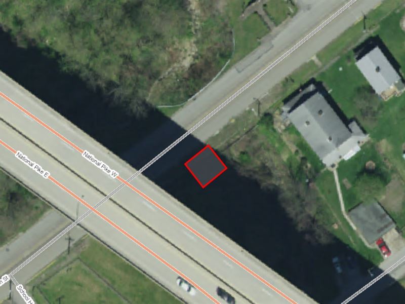
Street Address: N/A, near Main St, Brownsville, PA 15417
Size: 0.01 acres
LOT Dimensions: 25 feet x 25 feet
Legal Description: All that certain piece of ground situated in West Brownsville Borough, fronting on Main Street Twenty five feet (25 ft.) and running back from said street Twenty five feet (25 ft.) continuing, (625) six hundred twenty-five square feet. The said piece of ground adjoins property now or formerly of H.D. Porter and lies east of said Porter property and next to a run which passes through the said Borough of West Brownsville, PA. Upon said lot there is now standing a two story frame building formerly used as the Borough building of said Borough.
Being the same lot of ground which was conveyed to J.D.S. Pringle, Burgess and Alfred S. Starr, Bion Moffitt, J.D. Eckles, Daniel Livingston, Cris S. Pringle and Cris B. Snider, Town Council of the Borough of West Brownsville, County of Washington and their successors in office, by deed of James L. Bowman dated April 18, l893, and recorded in the Recorder's Office of Washington County, Pennsylvania, in Deed Book 187, page 204.
Together with all and singular the land, improvements, ways, waters, water courses, rights, liberties, privileges, hereditaments and appurtenances whatsoever thereunto belonging, or in anywise appertaining, and the reversions and remainders, rents, issues and profits thereof, and all the estate, right, title, interest, property, claim and demand whatsoever of the said party of the first part, in law, equity or otherwise howsoever, of, in and to the same and every part thereof.
Being the same real property as described under that certain deed of record at Book 926, page 85, Register of Deeds, Washington County, Pennsylvania.
Lat/Long Coordinates:
Nw: 40.026191, -79.887071
Ne: 40.026138, -79.887019
Sw: 40.026095, -79.887087
Se: 40.026147, -79.887141
Additional Coordinates:
North: 40.026191, -79.887071
East: 40.026138, -79.887019
South: 40.026095, -79.887087
West: 40.026147, -79.887141
Elevation: 770 feet
ANNUAL Taxes: Approx. per year
ZONING: The zoning on this parcel is residential.
FLOOD Zone: Yes
HOA/POA: No
IMPROVEMENTS: None
ACCESS: Property is bordering Main St.
WATER: None
SEWER: None
UTILITIES: There are power lines along Main St. Phone by cellular, satellite Tv/Internet/Phone