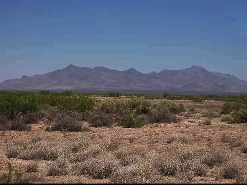
Off Grid Near Wilderness Areas
Ludlow, CA 92338
San Bernardino County, California
Lot Description
2.5 Acres (108,900 Sq. feet) Off Grid
Very Little Private Land For Sale In This Area.
Hiking, Biking, Off Road, Orv, Camping, Mountain Wilderness Areas, You Name It.
Located in the Mojave Desert, between Barstow and Needles, California in San Bernardino County, California. about 3/4 mile north of historic U.S. Route 66-National Old Trails Highway and of Interstate 40, and West of the town of Ludlow.
Single Family Residential Allowed-Make A Great Get-Away Very Private.
Allowed:
-New Construction Single Family Home
-Solar
-CAMPING Allowed - Drive Your Camper Right TO The Property - Excellent Location For Weekend Camping - Visit Nearby Wilderness Areas, Mountains, Hiking, ORV Riding, Atv's.
-Tiny Home Allowed
-Wind Energy Allowed
Terms Or (First month installment) (Processing) Installments of - Paid In 23 Months
Processing Payments: Direct Deposit, Cashiers Check, Bank Checks, Money Order, Personal Check, Zelle, Master Card, Visa, All Major Credit Cards, PayPal
Surrounded By Wilderness Areas-Bristol Mountain Wilderness, Kelso Dunes Wilderness, Cady Mountains Wilderness, Rodman Mountains Wilderness, Newberry Mountains Wilderness
Borders Thousands Of Acres Of Blm Land Creating Many Recreational Opportunities
Priced Lower Than Most Comparables
Near Newberry Springs
Rural Remote, No Neighbors Close-By
Each Side Of The Property Measures 330 Ft
Square In Shape.
Gps For 4 Corners (Approx.)
Ne: 34.747403, -116.294052
Se: 34.746481, -116.294052
Sw: 34.746481, -116.295117
Nw: 34.747406, -116.295117
Distance To:
Ludlow, Ca - 9 Miles
Newberry Springs, Ca - 24 Miles
Apple Valley, Ca - 77 Miles
Barstow, Ca - 45 Miles
Victorville, Ca - 75 Miles
Newport Beach, Ca - 164 Miles
Santa Monica, Ca - 173 Miles
Redondo Beach, Ca - 178 Miles
La - 158 Miles
Vegas - 154 Miles
Near Kern County Border
San Bernardino County properties are booming making this an excellent investment opportunity. The population in high desert have more than doubled in the past decade as people seek serenity and freedom from big cities.
County State Zip: San Bernardino County California 92338
Legal: Ne 1/4 Ne 1/4 Ne 1/4 Ne 1/4 Sec 36 Tp 8N R 6E 2.5 Ac
ACRES: 2.5 Acres (108,900 Sq. feet)
Zoning: Single Family Residential
Gps: 34.747034583, -116.294564407 Approx. Ctn
Access: Dirt Road
Water Elect Sewer: Off Yearly-Paid Current
Deed: Will Convey Title With Warranty Deed
Title: Free And Clear
About Newberry Springs:
The History of Newberry Springs, California
The Mojave Trail was the main route used by traders and pioneers making their way into California. It was opened in the late 1700S but became well used after 1850. It crossed the Mojave to the north of what is now Newberry Springs.
But by 1883, the railroad had reached the area, in a transcontinental link.
Railroad in Newberry Springs
That year, the Atlantic & Pacific Railroad (A & P) concluded its line across New Mexico and Arizona by crossing the Colorado River at Needles where it met its competitor, the Huntington and the Southern Pacific (Sp) railway which had also just finished its line that crossed the Mojave from Barstow.
The following year, A &P forced its rival to sell them the line (they began building their own line parallel to SP's) and in 1885 reached Los Angeles through Cajon Pass.
It was at this time (February 1993) that a key station was established: Newberry Springs a valuable source of water for the railway's steam locomotives.
The Name, Newberry Springs
SP railroad named the station Newberry (without the Springs part) after two brothers who lived there. But the first post office was named "Watson" after the first postmaster, Josiah Watson. It closed shortly after and reopened in 1899 with as "Newberry" but soon switched to "Wagner" after the postmistress Madge Wagner.
In 1919 the Atchison Topeka and Santa Fe Railroad (which had absorbed the AP RR in 1897) named the place "Water" due to its importance as a water source.
Finally in 1967 it was renamed "Newberry Springs" to distinguish it from "Newberry Park".
Another version says that it was named after Dr. John Strong Newberry (1822-1892) a physician and geologist, he was part of the Ives expedition along the Colorado River in 1857.
The surname is a locational one, derived from the many places called "Newbury", which in turn were named in Old English "newer" (new) and "burh" (town or fortress), as in "burg", therefore "new town".
About Ludlow:
The community settlement dates back to 1870S. The community of Ludlow was named after William Ludlow of Southern Pacific Railroads.
In 1882, the town was founded. The town started as a water stop for the Atlantic and Pacific Railroad. Ore was found in the nearby hills, leading to the town's boom.
From 1906 to 1940 it was the southern railhead for the Tonopah and Tidewater Railroad, operated by the Pacific Coast Borax Company and bringing borax and other mining products from Death Valley and Beatty, Nevada, to long distance Santa Fe Railway lines. It also served as the northern railhead for the Ludlow and Southern Railway, a mining line that ran south to the Bagdad-Chase gold mine and the mining camp of Rochester. It operated from 1903 to 1931.
Route 66
By the 1940S, local mining and railway activity had ceased and the town survived supplying the needs of travelers on the National Old Trails Road, renamed to become the legendary Route 66 in California. With Ludlow providing a Motor Court with bungalow cabins, the streamline modern Ludlow Café, a gasoline-service garage, and shade. They operated through the late 1960S. After Interstate 40 was built bypassing town there was little business and most residents departed, leaving ruins of empty buildings and Tamarisk trees that still stand flanking the old highway. Tourists following and exploring historic Route 66 pass through the ghost town now.
Chinese history
A Chinese family resided in Ludlow. Lee Yim, his wife Guishee Yim, and their five children lived in Ludlow. The family operated The Desert Inn Café and Hotel. The family lived in the community from 1914 to 1960S.
In 1917, there was a mineral deposit near Ludlow that began mining production in 1918. It was associated to Lavic Mining District. The mine is closed and it is part of Kelso Dunes Wilderness.
Geography
To the northwest on Interstate 40 are Newberry Springs and Barstow, California. To the east on Route 66 is Amboy, Amboy Crater, and Essex, and on Interstate 40 is Needles, California, and the Colorado River.
The Mojave National Preserve and Kelso Dunes, of the National Park Service, is to the northeast of town. To the west is Pisgah Crater in the Lavic Lake volcanic field. The Bullion Mountains are south behind the town, with the Bristol Mountains to the east and Cady Mountains to the northwest.
The Ludlow ZIP Code is 92338, and the community is in telephone area codes 442 and 760.
Climate
This area has a large amount of sunshine year round.