3.13 Acre Rural Escape
Kelley Rd : Annapolis, MO 63620
Iron County, Missouri
Lot Description
If you're looking to get away from it all, this remote and private property in Iron County, MO is for you.
This parcel is located on a well-maintained dirt road, just off 49 and down County Road 126. The feeling of quiet, privacy and remoteness is enhanced due to the fact that this parcel is surrounded by undeveloped lots - all the parcels that surround it are mostly wooded, with no improvements or structures on them.
The views in every direction from the lot are beautiful. The lot sits at the very top of a hill and has several miles worth of views in different directions. The tress on the property are about 50ft tall from the ground.
Building a home is permitted - single family homes or mobile homes allowed. This would also make a prime investment/hunting property, as there's a potential timber harvest available. Camping is permitted on this property up to 90 days/year, and campers/RVs are permitted. Hunting in the area is great - deer and turkey abound.
If you're looking for a bit more land, you're in luck: we also own the 5.23 acre property next door, which is also listed for sale (see details Here). We'd be happy to sell both to the same buyer for a package discount - call for more details.
This property is just 10 minutes from Annapolis, MO, which is a small town where you can access basic amenities such as a market, dollar store, post office, etc. It's a bit farther (30 mins) to Lesterville, a bigger town that has more options for general stores, churches, restaurants, etc.
For everything else, Farmington is just under an hour away. Here, you can find almost everything you could need: Wal Mart, Walgreens, hardware stores, doctors, many restaurants, hotels, activities and more. If you're wanting to get away to a big city, downtown St Louis is just 2 hours away.
This property is within close proximity to several of Missouri's best outdoor recreation spots. Just a few minutes away you can find:
Johnson's Shut-Ins State Park - The wilderness qualities and geology of the park and the surrounding St. Francois Mountains make a special place to visit. Its rugged character provides the perfect backdrop for camping, hiking, picnicking, splashing in the shut-ins, exploring nature or just relaxing.
Mark Twain National Forest - Missouri's only national forest. It's characterized by large permanent springs, caves, rocky barren glades, old volcanic mountains and nationally-recognized streams. It also has many beautiful rivers, lakes, and streams, offering a number of water activities, including boating and caoeing, and fishing. As for hiking, there are a wide variety of trails covering some 742 miles of the Ozarks. Trails differ greatly in length and difficulty. A few are restricted to hikers only, but many are open to mountain bikes and horses, and two areas are set aside for ATV and motorcycle enthusiasts. Mark Twain National Forest offers many campgrounds with spacious, secluded sites in a forested setting. Many are beside sparkling lakes or clear rivers. Some are located at trailheads.
Roger Pryor Pioneer Backcountry- Missouri's largest privately-owned forest. The foundation donates its lease of the more than 50 miles of the Trails of the Roger Pryor Pioneer Backcountry to the Missouri Department of Natural Resources for the enjoyment of visitors to Missouri State Parks.
Ozark National Scenic Riverway - Some of the best floating rivers you'll find anywhere - namely the Current and Jacks Fork Rivers. The clean, clear waters of the two beautiful rivers provide excellent opportunities for johnboating, canoeing, swimming, fishing, tubing, hiking and bird watching. Hunting is also allowed within the Riverways' boundaries, except around developed areas. The landscape is predominantly rural with oak-pine forests and occasional open fields. Fishing, hunting, and johnboating continue to gain in popularity. However, camping, canoeing, floating in tubes and sightseeing are the most popular recreation activities at Ozark Nsr. Horseback riding, picnicking and hiking are also popular activities. Most hiking is done in the spring and fall seasons.
The owner of this property will qualify for the Missouri Department of Conservation's free landowner permit for deer and turkey hunting.
Lot Info:
3.13 Acres
Iron County, Missouri; 63388
Subdivision: Hidden Valley Lakes
Community HOA Rules/CC+Rs Here
Nearest cities/towns: Fredericktown and Farmington
Apn: 17-1.0-01-00-00.27S0
Legal Description: Section: 1; Twp: 31; Rng: 3E; Block: ; Lot: ; Deeded Acres: 3.130 PT Lot 1 Nw1/4 - TR K-2
This property is NOT in a flood zone.
Elevation: 926 Ft
Terrain: Gently sloping, mostly flat
Access: Direct access to the properties via a well-maintained dirt road.
Septic system required - No perc test required.
Water: Well required.
Electricity: Provided by Black River Electric Coop which has service in the area. They can be reached at.
Annual Taxes: in 2019 (No, that's not a typo; taxes are Three dollars.)
HOA: (mainly covers road maintenance)
Zoning: currently zoned as Agricultural Land
Single Family Residence approved - must be larger than 700 Sf
Single/Double-Wide mobile homes allowed
50 ft setback from road
Camping/Recreational use approved: you may camp on the property up to 90 days/year, maximum 30 consecutive days.
RVs/campers are allowed on the property.
Iron County Website + Contacts
1 hour from Farmington
50 minutes from Fredericktown
2 hours from St Louis
10 minutes from Annapolis
27 minutes from Lesterville
VIEWING Instructions: You can go view the property at your convenience. Owner does not need to accompany. Please call/text us to let us know you're heading out, so we can ensure we have our phone on us in case you need help or have any questions. We'd appreciate a couple hours notice if possible.
Because this property is vacant, there is no physical address, so you can navigate to the property using either the GPS coordinates (mentioned above), or by using this GoogleMaps Link.
From this link, you can press “Directions” (on the left), enter your starting point, and GoogleMaps will provide you with step-by-step directions from wherever you're coming from.
You can also click “Send to Phone” if you're viewing this on your computer, and you'll receive a text message with the link to this map on your phone.
We highly recommend that you click “Save” to download the directions before you head to the property, so they'll still work if you lose cell service.
Detailed notes on how to find and access the property:
The entrance to the area is on HWY 49 and is marked by Chevron Sierra Land Co. signs as well as a post office and a storage facility. Main Street winds upward into the hills on a loose gravel road where it eventually splits into Hidden Valley Lakes. As you head north, you will pass several marked lots with no trespassing signs and one or two locked gates that lead onto different plots of land.
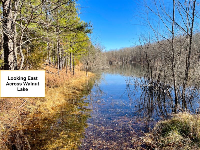
To access the parcel, take Garner Road which swings left at the top of a hill and leads you back down a hill past a small ranch over looking Walnut Lake. As you reach the bottom of the hill, you will pass right by the west side of the lake and swing over the small spillway drainage flowing west. Once you pass the lake, there is a 180 degree turn up a hill which brings you back to hidden valley lakes and all the way up to the corner of the lot at Kelley Road and Hidden Valley Lakes.
The lots are easy to spot based on the symmetry of the road surrounding them and the folds in the landscape along the north end leading into a creek bed. The south side of the lots is a straight drive with clearings on both sides of the road for views southward over the hills and northward into the property. Just past the property are a cabin on the right hand side of the road and a nearby neighbor on the left hand side of the road, so if you pass these you've gone too far. Please make sure not to park in an area which blocks the neighbors access to the road or their properties. Thanks.
PLEASE Note. The roads leading to and from the property can be bumpy/rocky with larger rocks in the road in some places. A small car could make the journey but we recommend a raised vehicle like a truck or an SUV for the drive in and out of the neighborhood.
PLEASE Note. To walk the property lines, we highly recommend an app called OnX Hunt, which uses your phone's GPS system to show you property boundary lines, and allow you to walk them in real-time. Especially because this parcel is mostly wooded, with no “landmarks” (ie a home) and is surrounded by other vacant/wooded parcels, this will be Very helpful in showing you where the parcel's boundaries lie. They have a 7-day free trial, so you can download the app and use it for free. Just remember to cancel before the trial ends so you aren't charged. Additionally - because cell phone reception can be spotty, please ensure that you Download the parcel map from OnXMaps before you go. If you have any questions about how to use OnX Hunt to walk the property lines, or download the directions, please call us before you go down to the property so we can walk you through it.